On the summer day that I hiked it, there were a lot of people at the top of Mt. Chocorua in the Sandwich Range of the White Mountains. I was surprised to see them, because I didn’t hear them from down below, even as I neared the summit. The entire way up the mountain, I had seen a tiny handful of people, yet here were much more than a handful. Most had come up the trail on the other side, and though I knew the mountain was popular, I had no idea that I’d end up among so many people. Groups, some quite large, were sitting all over the boulder-strewn top. A few dogs cavorted among them, showing off their four-wheel-drive agility on the rocks. Despite my surprise and even disappointment at seeing so much humanity so suddenly after such a quiet hike, I also felt the companionability common to hikers. As I reached the top, several nodded and greeted me. I spent a few minutes wandering the mountaintop, making sure to tap my toe on the U.S. Geological Survey summit marker, and eventually settled on a spot facing the Presidential Range to eat my lunch.

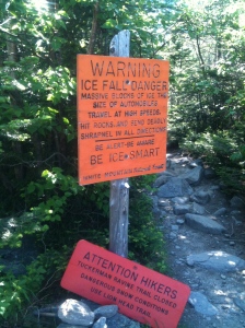
Winter-related hazards can await in Tuckerman Ravine, even in late June.
Mt. Washington’s broad shoulders were visible, though the peak was lost in gray clouds. In a line from Mt. Washington, I thought I could make out Mt. Monroe’s asymmetrical peak and Mt. Eisenhower’s domed pate, and I thought about standing atop each just over a month earlier. The White Mountains of New Hampshire are beautiful and rugged and unpredictable. Though they lack the altitude of the Sierras, Cascades, or Rockies, I sometimes describe them the way I describe certain basketball players: they play taller than their height. They spring from fairly low-lying surroundings, making for plenty of elevation gain. And they sit at a spot where significant weather patterns converge. Dangerously high winds are possible on the ridges and peaks, particularly in the Presidential Range; even when not dangerous, the wind is almost always strong. Clouds can roll in and descend in an instant, taking visibility down to nearly nothing and making you grateful that the high-elevation trails are marked by huge cairns. Those clouds can chill you to the bone, and sudden snowstorms have occurred even in the summer months. Hypothermia is a constant threat. The tree line dips below 4,000 feet. Jutting upward to meet the wind and storms, the mountains help make the weather, and the weather, in turn, remakes the mountains.
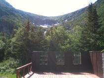
Experiencing the Whites is about the weather and so much more. The hikes up to the peaks and ridges run through beautiful forests and along swift streams before bursting above tree line into fields of boulders. On the ridges that run between the peaks, the views on either side stretch out before you in a magnificent quilt of rocks and trees that runs to the next set of mountains. Nestled below the shoulders of Mt. Washington are two vast, steep bowls: Tuckerman Ravine and Huntington Ravine. Curved and oriented perfectly to capture winter storms, Tuckerman develops a tremendous snowpack during the winter, and the trail up the headwall doesn’t open until approximately midsummer. Huntington is steeper, harsher, riven and jagged. The hike up it is considered one of the most challenging in the Whites; hiking down is too difficult and dangerous for most. Roughly between the two ravines runs a trail through the Alpine Garden, a rocky meadow of sedges marked by a variety of alpine flowers, the likes of which I’ve only seen at much higher altitudes in the Sierras, Cascades, and Rockies.

Tuckerman Ravine from the ranger station near its base.
The trails up to the ridges and peaks of the Whites have very few switchbacks. They just go up, which sounds practical enough when I write it here but can feel kind of insane when you’re actually hiking. When I was in high school in Los Angeles, where we were perhaps a little too “blessed” by interesting geological features and events, one of my best friends and I frequently went hiking in the Santa Monica Mountains. The Santa Monicas run right to the sea, and parts of them – even near the city – are remote enough that you can lose yourself in them. That’s all we wanted to do. One of our favorite hikes started on the Chumash Trail, an old Chumash Indian route that shot straight up to a ridge from the coast on a thin ribbon of soil through low brush and prickly pear. No switchbacks. Trails in the Whites are like that, too, but longer and far rockier. On the Chumash, I was always surprised to turn around after just a little while, quads and calves burning, and see that the car already looked tiny far below next to the grey of the Pacific Coast Highway, the yellow sand, and the sparkling ocean. In the Whites, the surprise comes as you suddenly emerge above tree line into the alpine domain, and you turn and take in a view that makes you wonder why you hadn’t done all of this sooner.
Most days, I would like to walk up a mountain. That feeling started for me in Yosemite National Park and the Mammoth Lakes region of the Sierras, and it continued in the Santa Monicas and Lassen Volcanic National Park and the Cascades and the Rockies. The Whites have found a place in my heart, too, even though my experience of them is limited to just a couple of trips. I plan to take many more over the years, including this summer.
It is rare for a day to go by without me thinking about how nice it would be to be heading upward.